
|
|||||||||||
|
|
|
|||||||||
|
|
|||||||||||
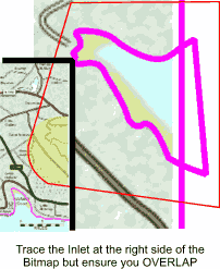
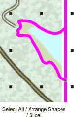
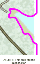
Select all (should be 2 objects) Arrange / Combine shapes / Slice. Hit delete. This extracts the inlet shape from the coastline shape.
Did it work? It should have. If not use Xara's best tool, the undo tool, and repeat the above. That's all the seaward objects created. Now we need to look at the lakes etc. inland, Set the line colour to GREEN.
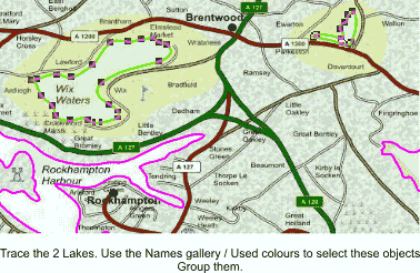
Zoom into the first lake. Trace around it's shoreline until its a closed shape. There's a smaller lake towards the top right corner. Trace this as well. Now you've completed both lakes. The above method hasn't got a lot of advantage over shift-selecting in this case but it can be very useful if you've created a lot of shapes
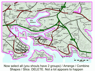
you wish to select several objects in a vast sea of shapes. Now Select all (should be 2 groups) / Combine shapes / Slice. Delete. Nothing really much will appear to have happened.
Open the layers gallery and make the 10SEA layer visible.
I'm going to have a beer now, so you can go and have a coffee. The next bit's very simple but effective, so I need you sober!
You're back. Okay set 10SEA & COAST layers to not visible not editable, so just the BITMAP layer is visible but not editable. Create a new layer and rename it TRUNK RDS (GREEN) (or MOTORWAYS or INTERSTATES whatever)
TIP:
You can rearrange layers in the layers gallery's layer stack by select-dragging them up or down if there not in the correct position. We want the TRUNK RDS (GREEN) layer on top. Now on my map the trunk roads are green. (That's why I also gave it the GREEN name in brackets, as were going to have 4 road layers eventually and it makes it very simple to select
the layer we want later). Zoom into a reasonable work area of green road and with the LINE colour set to a distinct colour that will stand out from the bitmap below, trace the line of the trunk road. Do this for all
the green sections of road on the map. |
|
 Select all (should be one group). Set LINE colour to black, FILL colour to a very pale green.
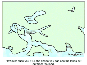 The land should now appear as one block, with the lakes as holes and the bitmap visible behind.